RICHMOND, Va. (WRIC) — Sunday night into Monday morning, calls for the high-pressure system that’s been in charge on our Sunday, to slide off to the east overnight tonight which will begin our highly anticipated warming trend for the new work week!

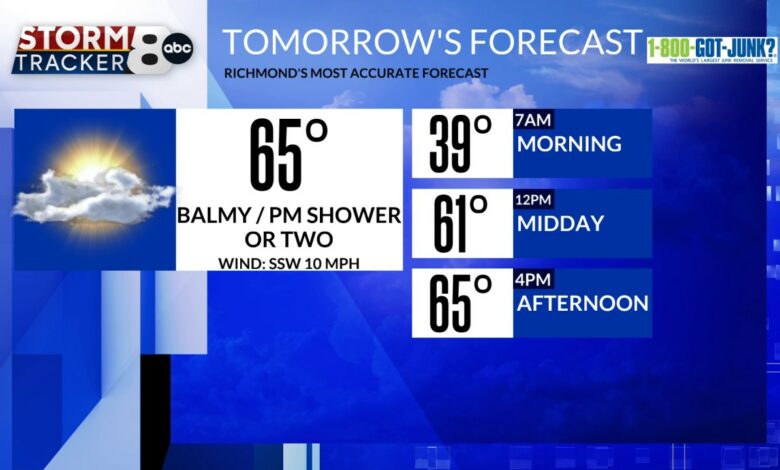
Monday morning starts off under partly cloudy skies and temperatures in the middle to upper 30s, so a light puffy coat is needed as you head back to work and school, for the new week ahead.

Monday afternoon finishes off under partly cloudy skies, balmy afternoon temperatures rising into the middle 60s with an afternoon shower or two possible.

Tuesday’s forecast calls for mostly cloudy skies, balmy high temperatures rising to 65-70 degrees and light rain showers possible.
Wednesday’s forecast calls for mostly cloudy skies, very balmy high temperatures rising to around 70 degrees and late day rain showers developing.
These Wednesday evening and nighttime rain showers will be heavy at times, and it will also be windy from time to time too on our Wednesday as this stronger surface cold frontal passage sweeps through the region on our Wednesday night.

Thursday’s forecast calls for partly cloudy skies and cooler high temperatures only rising to 45-50 degrees.
Friday’s forecast calls for mostly cloudy skies, high temperatures rising into the middle 50s and I put “watching” for now because there’s lots of uncertainty in the modeling for what may or may not occur on Friday into Friday night.
Next weekend calls for balmy high temperatures, both days with highs rising into the 60s under lots of clouds and a possible shower chance both days as well.
Next Monday calls for mostly cloudy skies and balmy high temperatures rising to 65-70 degrees.

Source link