Conny Waters – AncientPages.com – Dinas Powys, Glamorgan, located about 9km southwest of Cardiff, is a small inland fort of approximately 0.35ha. The hillfort was first excavated by a team of archaeologists led by Leslie Alcock from 1954 through to 1958.
The site is often referenced as a prime example of elite settlements in post-Roman western Britain.

Dinas Powys location. Image source
The excavator’s original chronology of this Iron Age hillfort continues to be cited in many sources. However, his interpretation and dating of the main defenses as a Norman-period castle – were disproven in the 1990s.

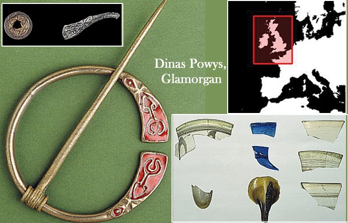
Reconstruction of a penannular brooch, based on a fragment of a mould die found at Dinas Powys (© Amgueddfa Cymru National Museum Wales).
Alcock’s archaeological work from 1953 to 1958 at Dinas Powys, uncovered what was then and still is the most extensive collection of post-Roman artifacts (from the fifth to seventh century) in Wales. This significant discovery serves as a globally recognized case study.
The understanding of the European ‘Late Antique hillfort phenomenon’ is unfortunately hindered by a couple of factors. These include the scarcity of large-scale excavations and an insufficiency of reliable dating evidence.
Dinas Powys is a unique case study for understanding the development of post-Roman society in a lowland area of the western Roman Empire.
Interestingly, this region remained untouched by ‘barbarian’ invasions during the fifth and sixth centuries AD.

Selection of artefacts, clockwise from top right: Phocaean red slipware; fragment of lead mould die; copper-alloy mount; millefiori glass rod; crucible; Atlantic and Anglo-Saxon tradition glass (© Amgueddfa Cymru National Museum Wales) (figure by Mark Lodwick).
In his research, Alcock argued that Dinas Powys (early medieval site), was ‘the court (llys) and hall (neuadd) of a chieftain’ of the emergent post-Roman kingdom of Glywysing.
Alcock’s excavations are truly noteworthy on a global scale due to the sheer size and variety of discoveries made. Dinas Powys still holds a significant place in historical and archaeological studies, not just within Wales but also internationally.
However, there are still unresolved questions about the site’s timeline. Alcock’s analysis of the excavation findings was complicated by the site’s intricate and disrupted layers of soil and rock. There was also an absence of scientific dating methods and outdated excavation techniques used at that time.
This study’s results is a culmination of over three decades of rigorous research, aimed at challenging and refining the site chronology of Dinas Powys. It introduces more reliable absolute dates derived from a fresh radiocarbon dating program, which is being presented in this work for the first time.
The researchers have worked much to introduce significant implications for the interpretation of Dinas Powys, the prominent early medieval site in Wales. Additionally, it contributes to our comprehension of post-Roman western Britain and the reoccupation of Late Antique hilltop sites on a broader scale.
Dinas Powys is enclosed by four sets of banks and ditches that enclose the fort’s southern side. Three of the four banks measure a minimum of 6m in width and 4m in height from the top of the bank to the base of the ditch, encompassing an area of 0.25 hectares.

Laser scan of the promontory fort earthworks at Dinas Powys (figure by Andy Seaman).
The arrangement of the earthworks indicates that bank 2 was likely built first. This was then followed by the construction of banks 1 and 3, with bank 4 being the last to erect.
However, it’s worth noting that only 0.1 hectares – constitutes the enclosed interior space.
“Approximately 140m to the south lies a second set of earthworks referred to
by Alcock as the ‘Southern Banks’ but officially known as the Ty’n-y-Coed earthworks. These earthworks consist of two sections of bank and ditch forming the north-west and north-east sides of a partial enclosure with dimensions of at least 60m north-east by 50m south-west,” the authors wrote in the paper.
The fort occupies the tip of a prominent hump-like ridge, with the terrain sharply declining on all sides, but today, the site is densely wooded. However, a recent terrestrial laser scanning program captures large objects and environments, clearly depicts the defenses as great and impressive in appearance, “which stands in contrast to the small area enclosed.”
Written by Conny Waters – AncientPages.com Staff Writer