Conny Waters – AncientPages.com – Using a ‘walkover survey,’ a small team of archaeologists from the University of Leicester Archaeological Services surveyed and recorded visible archaeological remains of the Eastern Sovereign Base Area (ESBA) at Dhekelia (ESBA) on the island’s south coast.

One small part of the celebrated Hellenistic tomb complex near Paphos, Tomb of the Kings—a World Heritage Site. Credit: ULAS, University of Leicester
Over forty archaeological sites in Cyprus, possibly dating back to the Bronze Age and previously believed to be lost forever, have been rediscovered.
The University of Leicester ‘s archaeologists have been working at the site of Dhekelia (30km southeast of Nicosia and 80km northeast of the Western Sovereign Base Area (WSBA) at Akrotiri, since 2015.
The goal was to relocate around 60 possible archaeological sites that had been recorded in the early 1960s prior to the development of the garrison within the Dhekelia base and the laying out of the Kingsfield Airstrip at the western end of the area.
Archaeologists then visited each site and searched for previously recorded evidence. When successfully found, each site was photographed, GPS-located, and recorded on pro forma sheets.
Researchers identified 51 sites in total, which include five historical buildings. Some records for 47 of these ancient sites survived, but the remaining four are only known from labels on a map with a scale of 1:25,000.

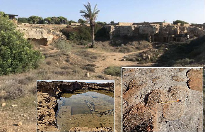
Adjacent grinding stone removals at Ormideia leaving a clover leaf shape. Credit: ULAS, University of Leicester
The exact ages of most sites are unknown, for now, but they probably range from the Bronze Age (around 2500 BC) to the Byzantine period (ending in the 12th Century AD).
This range likely encompasses sites from both the Hellenistic era (312—58 BC) and Roman times (58 BC—395 AD).
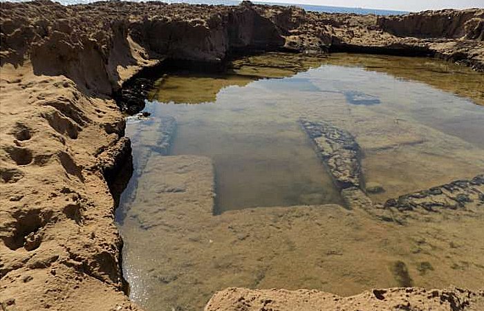
Particularly worth noting are three coastal quarries where stones were being extracted from shallow strips extending into the sea.
One quarry featured a small ramp, seemingly used for loading chunks of quarried stone onto boats moored in the deep water nearby. Another quarry was marked by numerous distinct circular impressions, likely from grinding stone removals. These were closely spaced, creating unique clover leaf patterns on the bedrock.
In one part of the inland plateau, large areas of rock-cut tombs extended over several hectares. Most of these tombs were very poor, and some bore clear signs of robbing.
Slab quarrying near Xylophagou anchorage. Credit: ULAS, University of Leicester
“Our GIS and survey methods had worked well when used for a similar survey of the Akrotiri peninsula in 2019. Many of the sites we were planning to survey had been last visited over 20 years ago, and in many instances had been reported as no longer existing or being unfindable,” Matt Beamish from the University of Leicester Archaeological Services, who led the survey, said in a press release.
“On reflection, this had more to do with inadequate mapping, lack of preparation, and lack of satellite location technologies: we found that many of the sites could be re-found with a little bit of patience.”
“There were undoubtedly problems with some of the archive information, which was incomplete and had been inaccurately redrawn at some stage in the past. Some sites had clearly been lost to the subsequent development of roads and buildings.”

ULAS Archaeologist Matt Beamish recording a probable Byzantine period tomb near Xylotymbou. Credit: ULAS, University of Leicester
Cyprus, strategically located on Mediterranean sea routes, boasts a rich and varied cultural legacy. It’s renowned for its commitment to preserving numerous archaeological sites dating back to various eras such as the Bronze Age, Hellenistic/Iron Age, Roman, Byzantine, and medieval periods.
A significant portion of the discovered archaeology in Dhekelia is related to burial practices, predominantly featuring rock-cut tombs. Some of these tombs were ingeniously constructed within limestone caves dating back to the Hellenistic or Iron Age periods. There are also rock-cut shaft graves that generally belong to the Byzantine, Roman, or Medieval eras.
“The survey was very successful with the identification of significant archaeological areas. We know that many more archaeological sites will exist which are not obvious to the naked eye,” Matt Beamish said.
“Much of the area has seen no systematic archaeological survey, and the application of remote sensing or aerial survey, perhaps using LiDAR, would enable a wider picture of previous human activity to be drawn.”
“The information will enable the DIO to manage better the archaeological sites within the Sovereign Base Administration Area and allow a wider understanding of Dhekelia’s archaeological heritage.”
Written by Conny Waters – AncientPages.com Staff Writer